 door
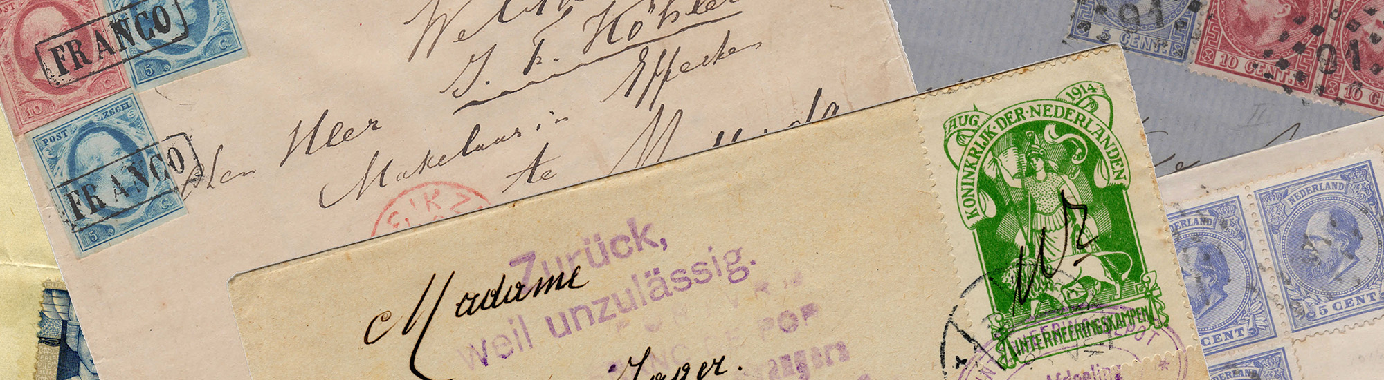
door ISSUE The first atlas ever was published in Antwerp in 1570, 450 years ago this year. To celebrate this, PostNL will be issuing the stamp sheet The first atlases on 23 March 2020. The six stamps on the sheet are dedicated to maps from six atlases that were published in the Netherlands in the 16th and 17th Century. The publishers of the six maps are depicted next to the maps. The stamps are marked ‘Internationaal 1′, the denomination for items up to 20g in weight destined for delivery outside of the Netherlands. The stamp sheet was designed by Studio Maud van Rossum from Amsterdam.
SUBJECT With its issue of The first atlases, PostNL focuses on unusual atlases that were published in the Low Countries in the 16th and 17th Century. At the time, the rapid developments in cartography were closely linked to the Netherlands’ leading position in international trade and shipping. Antwerp and Amsterdam were important centres for the atlas – a collection of maps of the same size and style, collected in a book of which multiple copies are made.

The creator of the first modern atlas was cartographer Abraham Ortelius (1527-1598). Ortelius collected the best maps available in his time. He either redrew or shrunk 53 in total, added descriptions, and collated them to create a book. This atlas was published for the very first time in 1570, 450 ago this year, in Latin, entitled Theatrum orbis terrarum (literally: ‘the theatre of the Earth’s surface’). A Dutch translation was published in 1571. This world atlas inspired many other publishers to create their own atlases.
In addition to Abraham Ortelius, the stamps feature the following publishers: Gerard de Jode (1509-1591), Gerard Mercator (1512-1594), Jodocus Hondius (1563-1612) Willem Jansz. Blaeu (1571-1638) and Johannes Janssonius (1588-1664). The publishers’ portraits on the stamps come from the image bank of the Rijksmuseum. All maps come from atlases from the Allard Pierson collection | The Collections of Amsterdam University. This collection broadly reflects the history of Western cartography, and Dutch cartography in particular. With its 175,000 map sheets and 5,000 atlases, the collection is one of the largest in the Netherlands and one of the larger ones in the world.
DESIGN Each of the six stamps of The first atlases features a map of the Low Countries, roughly consisting of what is now Belgium and the Netherlands. Next to the map you will find a portrait of the relevant publisher. The map is an engraving in colour, the portrait is a full-colour print executed in black and white. The portraits appear on the left on the three stamps on the left while the portraits appear on the right on the three stamps on the right. The tabs of the Priority logo feature the name of the relevant publisher plus the full name of his atlas. The denomination 1 appears above the picture of each publisher. The designation Nederland 2020 appears under the image, the designation internationaal is placed vertically in capitals, alternately on the left and right-hand side of the maps. The texts on the stamps and the sheet margin are printed in black and a muted blue. The six maps are featured on the stamp sheet in chronological order, from top to bottom and from left to right. This order is based on the year in which the atlas from which the map on the stamp originates was published. For example, the stamp on the bottom right features Johannes Janssonius’ atlas, which was published last, in 1666. Where required, the text mentions between brackets when the first edition of the atlas was published. In Janssonius’ case, this is 1638.
TYPOGRAPHY The typography uses two Dutch fonts: the Lexicon serif font (Bram de Does, 1992) and the Quadraat Sans sans-serif font (Fred Smeijers, 1996).
DESIGNER The stamps of The first atlases feature old geographical maps of the Low Countries together with a portrait of the relevant publisher. Maud van Rossum, who was responsible for the design of The first atlases is quite familiar with cartography as a subject. Together with Piet Gerards, Van Rossum designed the publication Afsetters en meester-afsetters. De kunst van het kleuren 1480-1720 by Truusje Goedings, published by Vantilt (2015). This book is about historic cartography and the art of colouring. Van Rossum also worked together with Piet Gerards to design various stamps for PostNL, including UNESCO World Heritage from 2014 and the two Inauguration stamps from 2013.

The first real atlas
In 2020 it will be 450 years since the first real atlas was published by Abraham Ortelius. “Which is why Ortelius appears prominently on the edge of the sheet,” explains Van Rossum. “While digging through this subject, we explored a number of ways we could go about the designs. For instance, I created a layout based on maps of the world as it was known at the time. For another variant I used paintings by Johannes Vermeer. Many of his works feature large geographical maps from various atlases of the period in the background. Ultimately, we presented PostNL with two completely different designs. One of the designs was limited to Ortelius and his first atlas. In this design, the same map of the Low Countries was repeated on each stamp. But every stamp featured a map from a different edition, coloured differently. The other design, which was chosen unanimously, shows which maps of the Low Countries Ortelius and his followers included in their atlases. One of the things that is unusual about this is that you can clearly see that in those days, North was not at the top of most maps. Because by tilting the maps, you could use expensive paper more efficiently.”
Considerations for the selection
Van Rossum imposed strict criteria on herself for the selection of the six publishers on the stamp sheet. For example, the publisher had to be born in the Netherlands, and the atlas had to include an image of the Netherlands. “The stamps are meant to be sent to international destinations,” according to Van Rossum. “That’s why I wanted to include the Netherlands as a calling card. But I had another criterion and that one was a tough one. Because I really wanted the stamps to feature a portrait of the publisher. That wasn’t so difficult for Mercator, Hondius, Blaeu, Ortelius and De Jode. But the last one was trickier. Finally, I found Jacob Colom, a publisher who’d created a tiny little atlas. He didn’t really fit in with the others, but I had to make do.”
Allard Pierson
But then, a stroke of luck. While working on The first atlases, Van Rossum was also working on the design of a book by Jos Biemans: Boeken voor de geleerde burgerij. De stadsbibliotheek van Amsterdam tot 1632. “In the copy I read that Allard Pierson | The Collections of the University of Amsterdam owns a large number of different editions of Ortelius’ first atlas. Conversations with two curators – Peter van der Krogt and Reinder Storm – revealed that other publishers were well-represented in their collection too. And, to top it off, they came up with a much better alternative to Jacob Colom: Johannes Janssonius. I’d heard of him, but I hadn’t found a portrait. However, on the title page of Janssonius’ atlas there is a group portrait that shows a man who, according to the experts, is definitely Janssonius. So that was the end of Jacob Colom – and my selection was complete.”
Fresh and unambiguous
The six maps from the atlases of the Allard Pierson were photographed by Stephan van der Linden. Then lithographer Marc Gijzen polished away any discolourations to create a fresh, clear picture. Van Rossum: “To improve legibility, the maps were printed on the stamps as large as possible by omitting the type margin of the atlas page whenever feasible. We only kept a narrow border to frame the map. We did keep the dent in the centre of the page. After all, the map comes from an atlas. The six maps have the same height, but the width varies. That’s caused by the ratios of the original maps. It was a bit tricky to get that right, especially on the stamp featuring De Jode. His map is wider than the others, so I had to do a bit of strategic rearrangement between the sorting mark and the denomination 1. It juuust fits! The De Jode map is also unusual for another reason: it’s the only map on the stamp sheet that isn’t coloured. It’s my nod to manual colouring, because in those days everything was coloured in by hand.”
Deeper black
The publishers’ portraits on the stamps come from the image bank of the Rijksmuseum. Van Rossum: ‘All portraits were detached and placed in front of the relevant map. That’s why it is less obvious that the maps have different widths. The lithographer changed all the portraits into full-colour black-and-white prints. This creates a deeper black and reduces the chance of moiré effects on the press.’
Rest and space
On the stamp sheet, Van Rossum used two fonts designed by Dutch font designers. Van Rossum: “They’re both fonts that create space and rest. The Lexicon serif font by Bram de Does is a really legible font with short stems, descenders and ascenders. That is why we were able to print the full – sometimes absurdly long – titles of the atlases on the tabs. The other font is the Quadraat Sans serif font by Fred Smeijers. It is a pointy, quirky font that matches the more traditional Lexicon surprisingly well. Right from the start, I opted for a muted blue as a spot colour to counteract the yellowish, warm tones of the maps. Both the fonts and the spot colour have been used to separate the various information layers.”
About the designer
After studying at Sint Lucas in Boxtel (1992-1996), Maud van Rossum (1974) continued her studies in graphic design at the Hogeschool voor de Kunsten in Arnhem (1996-2000). There she was taught by greats such as Gerard Schilder, Thomas Widdershoven and Pieter Hildering. In 2000 she joined Piet Gerard’s Ontwerpers, where Van Rossum designed numerous books for publishers such as Vantilt, NAi and 010 (now nai010), Bas Lubberhuizen, Lecturis and Athenaeum-Polak & Van Gennep. On 1st July 2018, she took over Piet Gerards Ontwerpers and continued the studio under her own name at a new location in Amsterdam. Studio Maud van Rossum has an approach that focuses on content. Client and subject are at the centre of the search for the ideal solution for each project. The design is restrained, precise and serviceable, with typography as the guiding element. Not only the design, but also text editing, image editing, materials, planning and production are tackled with the utmost of care. Studio Maud van Rossum specialises in book design. The studio also designs corporate styles, flyers, brochures, magazines, exhibitions and stamps. In addition, Van Rossum also does work for De Monsterkamer in Amsterdam, a physical and digital platform for paper and printed matter set up by Esther Krop. There she gives paper advice to visitors, works on an online paper database for graphic professionals and helps organise expert meetings. Since 2015, together with Esther Krop, Van Rossum has been putting her years of experience in the book business and knowledge of paper to good use to work on De Best Verzorgde Boeken. At the request of this foundation, they annually collect all technical data related to award-winning books for the catalogue.
SALE/VALIDITY The stamps are available while stocks last at the post office counter in Bruna shops and at www.postnl.nl/bijzondere-postzegels [in Dutch]. The stamps can also be ordered by phone from the Collect Club customer service on telephone number +31 (0)88 868 99 00. The validity period is indefinite.
VALUE The stamps are marked ‘Internationaal 1′, the denomination for items up to 20g in weight destined for delivery outside of the Netherlands.
TECHNICAL DATA
- Stamp size: 36 x 25mm
- Sheet size: 108 x 150mm
- Paper: normal with phosphor print
- Gum: gummed
- Printing technique: offset
- Printing colours: cyan, magenta, yellow and black
- Edition: 91,000 sheets
- Appearance: sheet of 6 stamps in 6 different designs
- Design: Studio Maud van Rossum
- Printing company: Joh. Enschedé Security Print, Haarlem
- Item number: 400361
SUMMARY
- Issue: The first atlases
- Issue date: 23 March 2020
- Presentation: sheet of 6 postage stamps in 6 designs
- Item number: 400361
- Design: Studio Maud van Rossum, Amsterdam
More about the design
The family of Abraham Ortelius (Antwerp 1527 – Antwerp 1598), whose name was actually Ortels or Hortels, originally came from Augsburg. Beginning as a map colourist, Ortelius became a member of the Guild of Saint Luke in Antwerp in 1547, supplementing his income by selling things such as books, manuscripts, maps, prints and medals. Ortelius collected the best maps and travelled regularly to check whether they corresponded with their respective areas. Above all, he was a business man who was keen on finishing his products as quickly as possible. This in contrast with Mercator, who was extremely critical of his sources and checked them thoroughly. However, the difference in approach did not stop them from regularly exchanging information. Ortelius’ most important work is the first atlas in history: Theatrum orbis terrarum from 1570. The stamp features a map from the Dutch edition of this atlas: Theatre, oft toonneel des aerdt-bodems (1571 edition).
Little is known about the early years of Gerard de Jode (Nijmegen 1509 – Antwerp 1591), until he made his appearance as a free-master of the Guild of Saint Luke in Antwerp in 1547. His Speculum orbis terrarum atlas from 1578 consists of two volumes, of which the second volume is titled Speculum geographicum totius germaniae imperium. De Jode and Abraham Ortelius were extremely competitive. Ortelius is reputed to have used his leading position to thwart his fellow cartographer. As a result, it took some time for De Jode to get permission to publish his atlas, eight years after Ortelius. The stamp features a map of the Netherlands from volume 2 of the atlas: Speculum orbis terrarum (1578 edition).
The founder of modern cartography is Gerard Mercator (Rupelmonde, aan de Schelde 1512 – Duisburg 1594). After studying in Louvain, Mercator, whose real name was Gerard Kremer, dedicated himself to mathematics and astronomy. He also worked as a surveyor. In 1538 he published his first world map, a double cordiform projection. In addition to maps, Mercator also produced globes and advised English sailors. In 1552 he left the Low Countries and settled working as a cosmographer for the Duke of Gulik in Duisburg (Germany). That is where he developed his famous Mercator projection. The stamp features his map of the XVII provincie de gli Paesi Bassi (1585 edition). In the 16th Century, the Hapsburg Low Countries were referred to as ‘The Seventeen Provinces’.
Jodocus Hondius (Wakken in West Flanders 1563 – Amsterdam 1612), real name Joost de Hondt, was a cartographer, engraver and calligrapher who acted as a publisher of large formats. For example, he published the Geographia by Ptolemaeus with the Greek text (1605) and the Gerardi Mercatori Atlas with a large number of added maps (1606). The latter was repeatedly reprinted and translated. His large Europakaart (map of Europe, 1595) is of great importance, as it was the first significant multi-part map of Europe since Mercator’s. In 1604, he bought up the copper plates of the Mercator atlas. He republished them in 1606, with the addition of 36 new maps, in the so-called Mercator-Hondius Atlas. He is considered to be one of the best cartographers of his era. After 1612, his widow took over the publishing house, later supported by her sons Jodocus jr. and Henricus. The stamp features a map from the Gerardi Mercatori Atlas (1619 edition).
Willem Jansz. Blaeu (Uitgeest or Alkmaar 1571 – Amsterdam 1638) was a pupil of the Danish astronomer Tycho Brahe, who taught him to make instruments and globes. Blaeu’s Earth and celestial globes surpassed everything that had appeared before, both in beauty and accuracy. Until 1630, Blaeu mainly focused on publishing nautical maps. His first land atlas did not appear until 1630. Blaeu had bought the copper plates of this atlas from the estate of Jodocus Hondius jr. In 1635, the first edition of the famous Atlas-Novus appeared in two volumes. Blaeu was also a great science enthusiast. At the beginning of the 17th Century, he discovered two new stars, and he performed numerous calculations to calculate the circumference of the Earth. The stamp features a map from the Atlas major (1662 edition). This atlas was published by Joan Blaeu, the son of Willem Jansz.
Johannes Janssonius (Arnhem 1588 – Amsterdam 1664), real name Johannes Jansz., was the son of a printer and publisher. In 1612, Janssonius married the daughter of Jodocus Hondius and settled in Amsterdam to publish maps and city books. Business ran smoothly, and soon Janssonius opened ‘buytenwinkels’ (branches) in Berlin, Frankfurt, Geneva, Lyon and Stockholm, among others. He also worked at his brother-in-law’s publishing house. At his initiative, the Mercator-Hondius Atlas was expanded and published as Atlas Novus, with editions in Dutch, French, Spanish and Latin. Like his contemporaries, Janssonius also made use of existing copper plates. The stamp features a map from the Ioannis Ianssonii Atlas contractus (1666 edition).
Sources: Ons Erfdeel, 12th volume, 1968, page 106, iets over de nederlandse kartografie, author Frans Weemaels, wikipedia.nl, vliz.be/hisgiskust/nl
COPYRIGHT © 2020 Koninklijke PostNL BV